SALTØY
SVEBUKTA
SVEBERG?
Main Pages
LOCATIONS
SVEE FARMS IN NORWAYFarm names associated with this family have been listed as Saltøy, Svebukta and Sveberg(h).
xxxxxxxxxxxxxxxxxxxxxxxxxxxxx SVEE FARMS IN NORWAY
SALTØY The oldest known farm associated with John Svee was on Saltøy (an island) on the north end of Fættenfjord, an arm of Åsenfjord, until the family moved to Svebukta on the mainland looking out to Saltøy.
Ancestors in the direct line with John Svee who lived on Saltøy included: *Arnt Jonson Saltøy 1710-1773 (John Svee's great-great grandfather). Arnt bought farm in 1750 and it was in the family until 1900. *Jon Arrntson Saltøy 1751-1836 (John Svee's great grandfather) Jon bought the farm from Arnt in 1779. *Andreas Jonson Saltøy 1782-1851 (John Svee's grandfather) Andreas' brother, Arnt Jonson, bought the farm from his father in 1823. Arnt Jonson's daughter Malena and her husband. Ola Jonson Skjervauran, bought the farm from Arnt in 1854. Malena and Ola's son, Jon Olson Saltøy bought the farm from them in 1891. Jon sold the farm in 1911 and it was no longer in the family. In the 1801 census there were 10 people living in the house at Saltøy.
During the years when tuberculosis was a significant problem in Norway, the island was purchased by a union of doctors who used the island as a place for poor people to recuperate from tuberculosis. The people would spend 3-4 weeks there, hopefully having rest and some sunshine, and then return home. A relative mentioned in September, 2005, that Norway is now experiencing a resurgence of tuberculosis because of people from Russia/Eastern Europe coming to Norway.
In 2008, Saltøy was owned by a "Fellesforbundet" (RAF), a trade union in Trøndheim, and is used as a resort/vacation place for its members. A cartaker and his wife live on the island and came in a boat to bring us to the island. The island had belonged to RAF since September 1949. After that it was bought by the public health district and used as a holiday place for children.
SVEBUKTA (Gård 47.6)
Ancestors in the direct line with John Svee who lived there included: *Andreas Jonson Saltøy 1782-1851 (John Svee's grandfather) *Jonas Andreason Svebukta (John Svee's father) 1821-1899 *John J. Svee (1855-1931) and his brothers and sisters including *Arnt and *Gunnerius The word "bukt" in Norwegian can mean a "bay" or "cove". Olav Vinge of Skatval and Ingrid Brechen of Lade thought that John Svee would have lived on a hussman plass which would have been part of Svebukta
SVEBERG To add confusion some family members have John Svee's birthplace and the family living at "Sveberg". There is a possibility that this Sveberg was part of Svebukta.
In 2005 (later in 2008 and 2019), we visited the location said to be the hussman plass where John Svee lived. The owner of the property took us to a location near his house where the foundation of the hussman plass was located. Today it is grown over with grass. The building had been torn down when the E-6 was built and part of the property is now under the E-6 motorway. It is possible that hussman plass was part of Svebukta and was Sveberg. Near Svebukta there is a point where families walked out to see if the fishing boats of their men were returning from the sea.
From the hussman plass and Svebukta, you could look out to Saltøy. You can also look out to Saltøy from Forbordfjellet, Steinvikholm, and the E-6 motorway as you drive past the end of the arm of the fjord. The owner said if I was related to Julie and Magnar Karlsen, then I was probably related to his 2 year-old daughter we saw playing on a swing set in the yard. My cousins, Janice Ray and her sister Marilyn, visited Svee farms with Julie and Magnar Karlsen in the 1970's. xxxxxxxxxxxxxxxxxxxxxxxxxxxxx
 |
 |
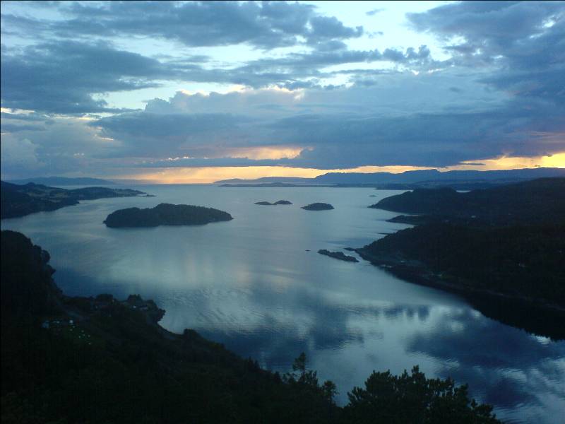
| Åsenfjord (in the
distance) Fættenfjord (in the forground). The larger island is Saltøy A fantastic shot from the Wikipedia website In the picture above,
on the mainland to the left is Svebukta, Sve gård,
Røkke, Fiskvik, Vinje - all farms/locations
associated with the Svee/Rokke/Vinge parts of my
family in Norway.
The bottom right of this picture is where the Germans hid the battleship Tirpitz from the allies in WWII. <Click to learn more about the Tirpitz in Fættenfjord further down this page> |
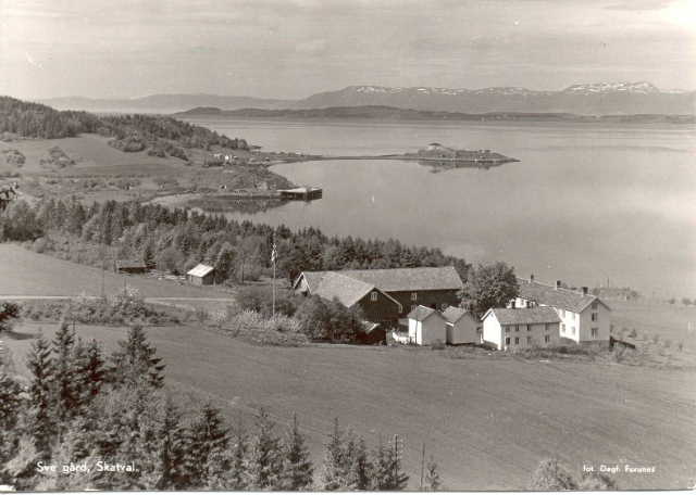
Sve Gård Farm 47 Steinvikholmen in the background Mary Iwen Lamp has this
postcard in her collection of photos from her
mother, Thena Svee Iwen (daughter of John Svee).
Sve Gård (47) is on the mainland across from Saltøy. There were several other place names at Sve where people said the ancestors of John Svee lived but the only one documented in the Skatval bygdebook was Skogset/Svebukta.47.6. The listing of the same family on Saltøy prior to Svebukta establishes that Skogset/Svebukta was John Svee's home. There are pictures showing Skogset as both 47.5 and 47.6. |
| After living on Saltøy,
records in bygdeboks list Svee family members as
living at Svebukta and using Svebukta as a family
surname. |
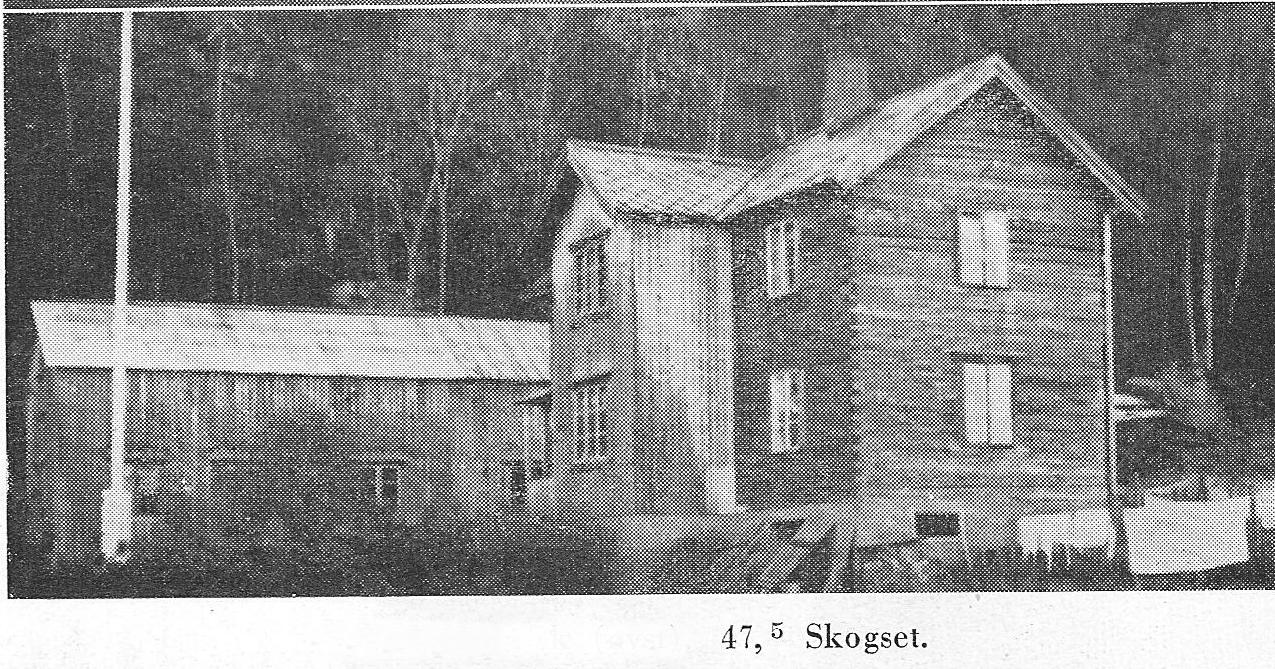 Picture
47,5 - Skogset. This picture adds to
the confustion as it is titled 47.5 when Skogset was
47.6. Picture
47,5 - Skogset. This picture adds to
the confustion as it is titled 47.5 when Skogset was
47.6.
|
 |
 |
| Old
picture - possibly "Sveberg"
(1970 photo) Thought by some family
members to be at the location of the hussman plass
where John Svee was said to have lived. This picture
is perhaps from when other relatives visited
Trønderlag in the 1970's. If correct, in the
distance to the right would be SALTØY. A note on the back of
the picture states "Svee home in Skatval".
|
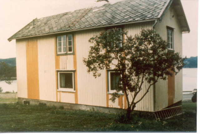
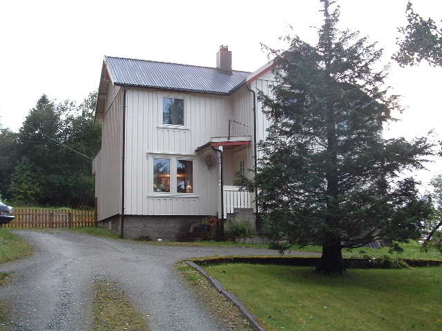
New
home - possibly at "Svebukta" (2005 photo)
When we took this picture above in 2005, the owner said that an old foundation just barely visible in the ground to the right of this house is possibly the location of the old "Sveberg" house (see picture below where I am standing on the old foundation). |
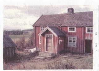 Birthplace of John J.
Svee? (1963 photo)
Written on the back of this
photo is the following:
**************************************"Skatvold Parish, Lower
Stordalen Norway.
**************************************Our father, John J. Svee was born in this house, Oct. 9, 1854. He came to America at the age of 21 yrs. in the year 1875. Married Beret Rokke in 1885. His parents were Johannes Svee and Elizabeth Arnestad. This picture was taken by Odd Rovick when he and his wife visited Norway. No Svee there now". The references to the
names of John's parents indicates that the writer
had incomplete knowledge about his/her parents.
I need to verify who wrote on the back of the
photo.
|
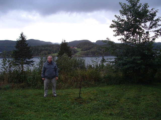 Hussman Plass of John J. Svee? Sveberg? As
seen from the location of the hussman plass where
John Svee was said to have lived. I am
standing on the location of the foundation of the
house and behind the house in the photograph
above. Behind me is a fence and below that is
a steep drop to the E-6 motorway. In the distance,
across the water behind me, is Saltøy.
There is another bruker named Sveberg in the bygdebook but no namve associated with John Svee's family are included with that listing. |
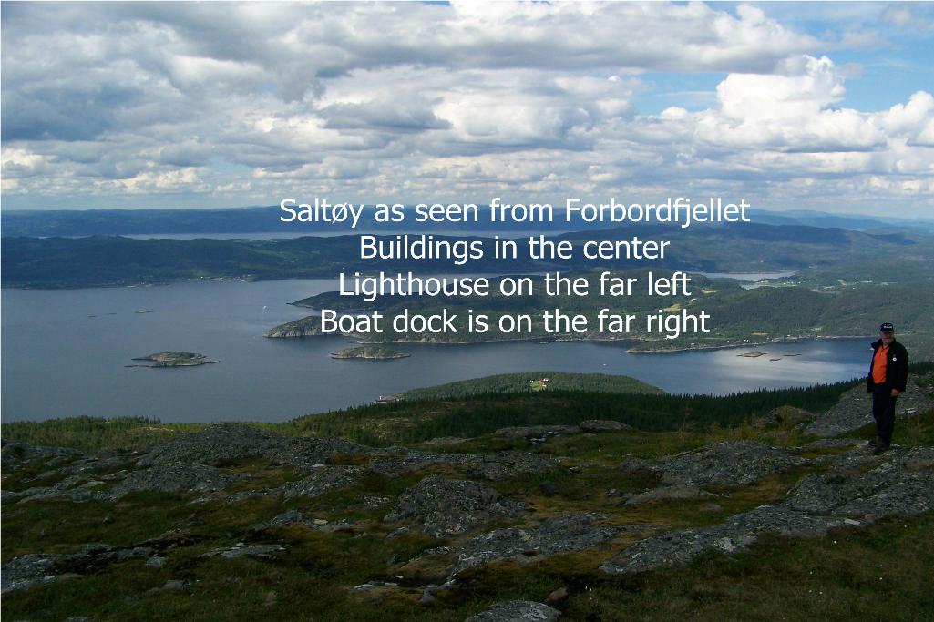 We
drove past the Skatval church up a private road to the
top of Forbordfjellet and looked out over Saltøy. We
drove past the Skatval church up a private road to the
top of Forbordfjellet and looked out over Saltøy.The picture shows about 1/2 of Saltøy. |
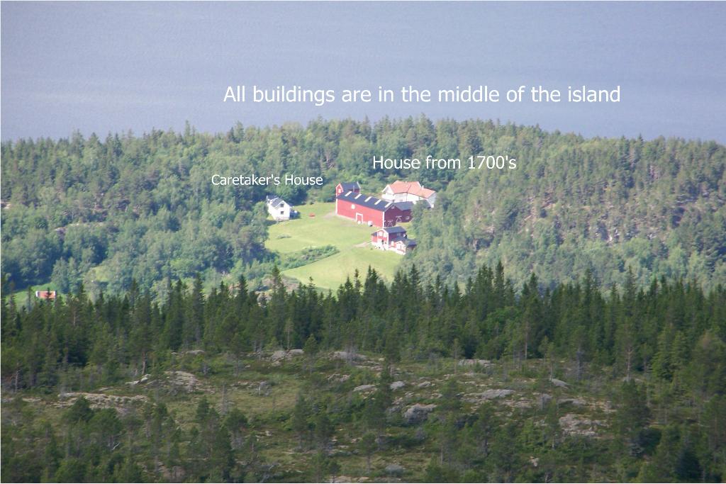 Zooming
in with a telephoto lens, you can see the
buildings on the island today. The large white
house goes back to the 1700's. Zooming
in with a telephoto lens, you can see the
buildings on the island today. The large white
house goes back to the 1700's. |
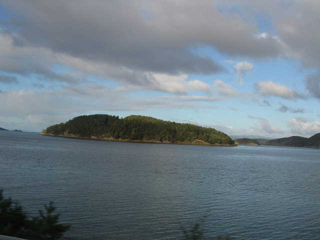 Saltøy - 2008
Picture (as seen from the E-6 motorway)
|
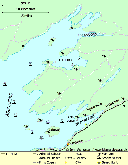 Location of the Tirpitz in relationship to Saltøy. Notice the flak guns on Saltøy and the small skerries next to it. |
| Learn more below about German battleships near the island during WWII. | |
  Tirpitz photo credits www.museumnett.no www.bismarck-class.dk |
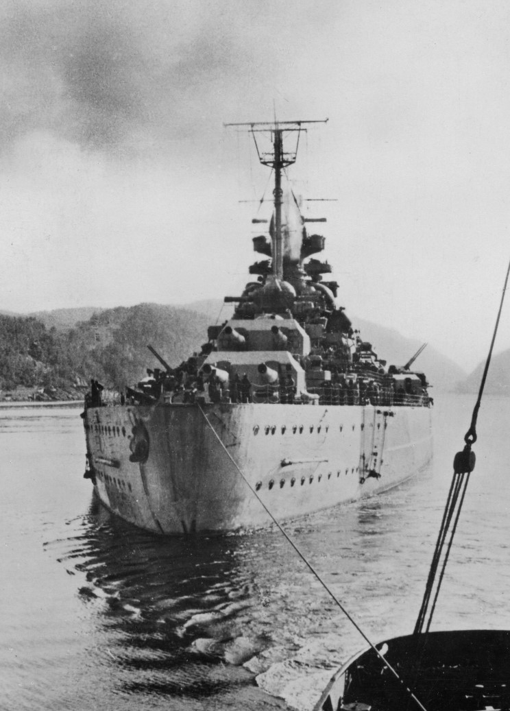 |
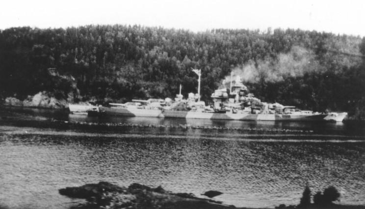
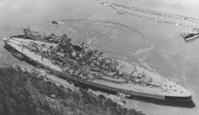
| Battleship Tirpitz, the sister ship of the Bismarck, in Fættenfjord in June, 1942 | On November 12, 1944
the Tirpitz was attacked and finally sank immediately
to the west of Tromsø, in the bay of Håkøybotn. |
THE BATTLESHIP TIRPITZ
In 1942, the battleship "Tirpitz", moored in Fættenfjord, was attacked by allied forces. The Tirpitz, the largest war ship built in Germany, was a sister-ship of the Bismarck and was seen as one of the most modern battleships in World War Two. When commissioned, It was the largest battle ship in the world until the Japanese "Yamato" was commissioned in December 1941.
14 January 1942 Tirpitz, escorted by the destroyers Richard Beitzen, Paul Jacobi, Bruno Heinemann and Z29, transferred from Wilhelmshaven, Germany to Trondheim, Norway. It was 4 days later than originally planned. Tirpitz arrived, together with the destroyers, at Trondheim in Norway and anchored in Fættenfjord 16 January 1942. Fættenfjord is the small arm of Åsenfjord just beyond the island of Saltøy, the Svee family ancestral home. Also, you look out onto Fættenfjord from Svebukta and Sveberg, both places of the Svee family.
On the map of Tirpitz locations above you can see the location of a German flak gun emplacement on Saltøy, and the surrounding area.
Saltoy was the landmark that the Halifax aircraft used as a reference point to line up bombing runs on Tirpitz in Fættenfjord
The Tirpitz was later sunk off Håkøy near Tromsø, Norway, in 1944.
Read more about the Tirpitz at: http://www.bismarck-class.dk/
Click on the following links for some great pictures of the Tirpitz in Fættenfjord. Notice Saltøy in some of the shots.
http://www.bismarck-class.dk/tirpitz/miscellaneous/tirpitz_faettenfjord_then_and_now/tirpitz_faettenfjord_then_and_now.html
http://www.bismarck-class.dk/tirpitz/gallery/themes/gallthemetirfaettenfjord.html
© Jon Satrum